My legs and feet were so swollen, I struggled to get my boots off after I sat down.
I had finished just three-fourths of a 19.4-kilometer hike (about 12 miles) with my husband, Mike McCall, and we were well into our descent. Ketetahi Hut was a brief respite of relief. We were behind schedule, but I needed to rest. Edema had set in. Everything was swollen. My gloves were tight. My pants were snug. My face hurt. My legs throbbed. My feet were so tender I could barely walk.
I'll admit, I'm not in the best shape. But I love to hike. Should I have attempted this trek over a live volcano? Probably not. But, darn it, I was in New Zealand, and I was going to complete the Tongariro Alpine Crossing.
In early 2015 when we started discussing this trip, we hadn't vacationed since 2008, and Hawaii was more on our radar (and more affordable) than New Zealand. On a whim we looked up New Zealand. Only $1,600 per ticket?
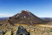
There was no debate or discussion. We were going. And the Alpine Crossing was a must. It traverses Tongariro National Park on New Zealand's North Island. It is among the most popular day hikes in the country, and is advertised as one of the finest one-day hikes in the world. Tongariro National Park includes a massif of three active volcanoes, Mounts Ruapehu, Tongariro and Ngauruhoe.
The vast majority of the Crossing is arid, volcanic terrain with little vegetation, and it's completely exposed to whatever weather Mother Nature throws at you: wind, cold, the relentless sun. It's all
in your face. "Be prepared for [23 Fahrenheit]," we were told. It wasn't something I wanted to hear.
We were there in late November, spring in New Zealand.
Spring is cold in New Zealand, very cold, at least it was on the Crossing.
On our hike day, 4:45 a.m. arrived with a jolt. As I opened the door, the air was sharp. It was easily well below freezing.
PLEASANT STROLL
The Crossing starts at Mangatepopo Carpark. From there, you head out in a nearly straight, flat line until you hit Soda Springs.
To protect the delicate volcanic terrain, much of the first two kilometers (about 1.2 miles) are atop a long wooden walkway, elevated like a boardwalk. We enjoyed the silence as we trekked along to Soda Springs.
This is the only easy part of the Crossing.
From Soda Springs, the route took us uphill to the South Crater via the Devil's Staircase. The name is fitting. This leg of the trail has well-formed steps built into the terrain and framed with wood. The steps are just wide enough to fit a hiking boot from heel to toe. It's like climbing a 328-yard staircase.
To put this in perspective: The Simmons Bank Tower in downtown Little Rock is 40 stories or 182 yards tall. Imagine climbing its stairwell about twice. And this was not your typical staircase. The angle was much steeper.
My problems began on Devil's Staircase.
My cardiovascular endurance is not great. After 20 or so steps, I needed to catch my breath. Pause. Twenty steps more. Pause. Repeat.
Thankfully, my trekking pole helped. And reaching the South Crater made the exertion worth it.
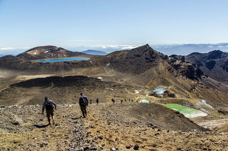
The crater is not a crater but a vast flat place sandwiched between Mount Tongariro to the left and Mount Ngauruhoe to the right. We still had more than 218 yards of lunar landscape to go before we reached the highest point of the Crossing -- the Red Crater.
It sits at an elevation of 2,063 yards above sea level, and it's a scramble to get there. Literally.
SLIP SLIDING AWAY
As we left the South Crater, the ascent started again with a small set of stairs, but then we were on our own. Most of this section goes up and over loose, volcanic rocks, gravel and sand. The higher we went, the harder the scramble. And stronger the winds. Chains were drilled into the rock so you could pull yourself up.
But the view from the top of the Red Crater was nothing short of incredible. I looked back onto the South Crater to see a steady stream of tiny hikers making their way toward the summit. Ahead lay the Emerald Lakes and beyond that, the Blue Lake.
The summit was crowded. At least three dozen hikers were strewn about. If people weren't resting or eating, they were taking photos, lots and lots of photos.
I could feel that my boots were getting a little snug, and I ignored it. But I did pry my wedding rings off, and I could see the imprint of the stones on my finger. I knew something was wrong.
LIVE VOLCANO
From the Red Crater Summit, the Crossing turns down a steep slope of loose scree and heads toward Emerald Lakes and Blue Lake. With each step, small rocks tumbled downhill. As I slowly walked down, there was a small rock ledge to my left. I grabbed it with my gloved hand to steady myself.
The ledge was hot. Very hot. It wasn't enough to burn, but it was hot enough to remind you of the geothermal activity going on underneath your feet.
We paused at the lowest of the lakes, a vibrant lapis blue pool, for another quick break. From here, the Crossing continues through the Central Crater. There is a fan-shaped flow of black lava spread across the floor of the Central Crater with Mount Ngauruhoe rising up in the distance.
The Crossing heads uphill one last time toward Blue Lake, a sparkling freshwater lake that formed in an old lava vent and is a vivid blue naturally. Like the Emerald Lakes, the water in Blue Lake is very acidic, with a pH about 5.
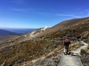
As we circled around the back side of Blue Lake, I saw the series of downhill switchbacks that lay ahead and our next stop, the Ketetahi Shelter.
GIMME SHELTER
The pathway toward the shelter was smooth with packed soil, but it was all downhill. The constant pounding on my feet and legs took a major toll on my strength and stamina. Ahead we could see plumes of steam escaping from Te Maari Crater, which erupted most recently near midnight Aug. 6, 2012.
At the shelter, a girl was offering up about a half-liter of water. I took it because I could feel that my CamelBak was close to being empty. I would come to appreciate the extra water.
My feet ached, so I took off my boots. I was afraid my feet would be bloody and blistered but, to my surprise, they were just a little red. But they hurt to the touch.
Three kilometers (about 2 miles) to go.
For the average hiker, the trek from Ketetahi Shelter to the Crossing's end at Ketetahi Carpark should take around two hours. For me, it took 3 1/2. I turned into a shuffler. The length of my normal stride was cut in half because I could barely walk.
The Crossing's last leg took us downhill on a series of wooden steps, which for me was beyond excruciating.
We dropped into a tree-covered forest and passed through dense shade. We crossed several footbridges over rushing streams.
The obvious dangers of the live volcanoes were behind us, but there were warning signs of other dangers ahead. A large section of the Crossing passes through the Lahar Hazard Zone, an area where volcanic mudflows can occur. Signs advise you to turn back if there is noise coming from upstream.
PARCHED
At this point, my feet and legs hurt so much that I stopped taking photos. I just didn't care anymore. I wanted it to end. But I had one more hurdle to face: thirst.
We ran out of water.
With an hour left to go, my CamelBak was dry and so was Mike's. It's advised that you take at least 1.5 L (about 1.6 quarts) of water when you head out on the Crossing, and that's exactly what each of us took. Had I not accepted that extra half liter from the girl giving away water, I would have run out much sooner and been in real trouble.
But I could hear the cars on the gravel parking lot. As finally we reached the Ketetahi Carpark, it was 4:05 p.m. and we'd missed the 3:30 shuttle bus.
We sat down to wait for the next pickup, at 4:30 p.m. As we waited, I eyed a half-empty bottle of water sitting on the deck. Someone had left it behind. I sent Mike to go fetch it. He pulled a LifeStraw filter from his backpack, and we drank that stranger's abandoned water.
My Fitbit read 34,754 (15.28 miles). I'd made it. I felt awful, and I knew my feet and legs would pay for this, but I'd made it.
I took my boots off one last time. I propped my legs up on a wooden post, and I cried.
Travel on 02/21/2016