The wettest February on record for much of Arkansas has come to an end after another band of thunderstorms pounded central and southeast Arkansas on Wednesday night.
Some parts of the waterlogged state already had received 15 inches of rain in February before the last round of storms moved through.
The rain should move out of central Arkansas around noon today and east Arkansas a few hours later, said Marty Trexler, senior meteorologist with the National Weather Service in North Little Rock.
"Then we'll have a dry spell through Saturday," he said.
Click here for larger versions
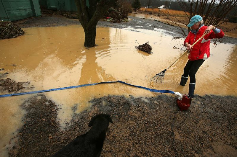
Photos by Thomas Metthe
Photos by Thomas Metthe
On Sunday and Monday, a front could bring another inch or 2 of rain across the state, said Trexler.
Officials in a dozen Arkansas counties have declared emergencies because of flooding, said Dan Noble, a spokesman with the Arkansas Department of Emergency Management. Those counties are Chicot, Clay, Clark, Cleveland, Faulkner, Lee, Lincoln, Logan, Mississippi, Ouachita, Randolph and White.
Noble said the counties were handling the problems locally as of Wednesday afternoon.
"We have not been asked for any assistance yet," he said.
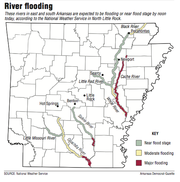
Seven Arkansas rivers were expected to be flooding or near flood stage by noon today, according to the National Weather Service. They are the Black, Cache, Little Red and White rivers in east Arkansas, and the Little Missouri, Ouachita and Saline rivers in south Arkansas.
P.K. Norman, emergency management director for Monroe County, said the White River was already 3 feet above flood stage at Clarendon on Wednesday afternoon, but the city is protected by levees.
Norman said the river is expected to rise from its current 29 feet to 33 feet by March 8. At that point, it could cause problems for people living along Maddox Bay, an oxbow lake east of the White River at Lawrenceville, 20 miles south of Clarendon.
"Those people go through this quite often," he said. "Most of them are down there now putting stuff up at a higher elevation."
The National Weather Service provided a list Monday of 42 locations in Arkansas that had set records for rainfall for February. The weather service has more than 100 reporting stations in the state.
By Wednesday, Star City, Fordyce and Monticello had received more than 15 inches of rain for the month.
Little Rock was at 11.93 inches of rain as of noon Wednesday, still shy of the record of 12.74 inches set in 1882.
In the White County town of Pangburn, heavy rains caused water to break through a pond's levee and sent it across Dripping Springs Road, a field, a gravel road and into some residential yards about 4 a.m. Wednesday.
After slamming into some of the homes, the pond water flowed into the Little Red River behind them, relieving any immediate danger of flooding, Pangburn Mayor David Wilson said. The houses escaped damage, and no evacuations were necessary.
Pangburn is about 12 miles southeast of Heber Springs.
Sandy Wilson, who lives in one of the houses on Landing Drive, said her dog's barking awakened her. Standing in the rain Wednesday, she recalled hearing what she thought was heavy wind.
"I looked out the window and saw it was water," Wilson said.
Wilson's son, Drew Wilson of Hot Springs, said his mother was fortunate that the pond water could drain into the river. Otherwise, he said, "It would have washed away the house."
Although the White River is above flood stage to the north around Clarendon, Thomas Best, the county judge in Arkansas County, said he doesn't think it will cause much trouble down his way.
"The river spreads out over bottomland," he said. "I don't think as of right now that it's going to be a threat to any residents of Arkansas County. We'll have a few county roads under water but we'll barricade them up, and I hope everyone stays safe."
Two-dozen sections of highway in south and east Arkansas remained closed late Wednesday because of high water, according to the Arkansas Department of Transportation's idrivearkansas.com website.
"We have enjoyed mild winters for the last couple of years," said Danny Straessle, a spokesman for the Transportation Department. "The water that has come down this February, like the spring last year, depending on what phase a project is in, it has impacted it. Contractors can't be out working in weather like this, particularly if they are moving dirt."
The rain also has been washing fill out of recently repaired potholes, Straessle said.
"There's really no solution for that other than a sunny day," he said.
Metro on 03/01/2018