5 p.m. update:
Arkansans likely won't see a major winter storm on Martin Luther King Jr. Day, but some can expect light snowfall, forecasters said Friday evening.
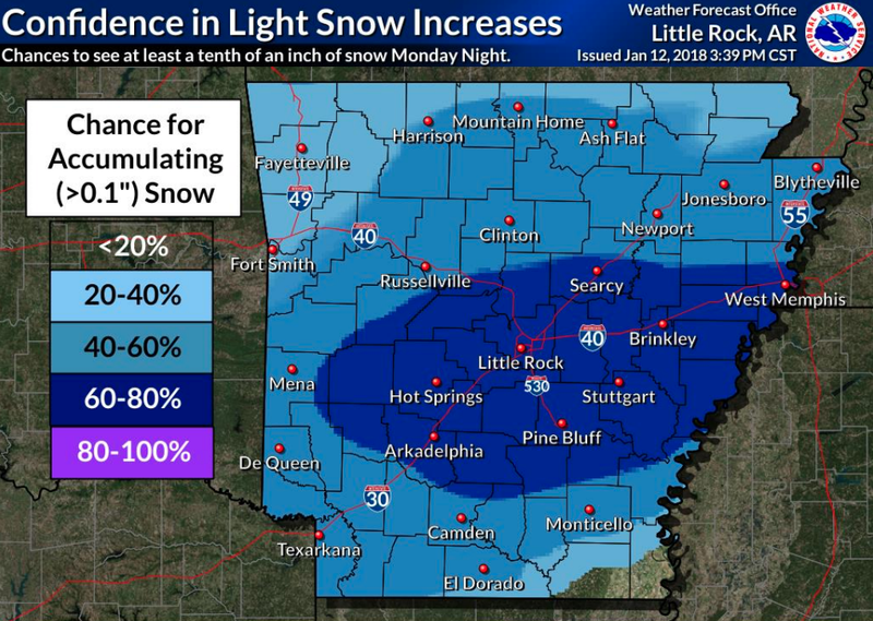
The National Weather Service predicts snowfall accumulation of more than one-tenth of an inch for much of central and eastern Arkansas starting Monday evening. Lighter accumulation in much of the state was also said to be possible.
The total snowfall will likely be about 1 inch or less, forecasters noted.
The state will also see much colder temperatures Monday night through Wednesday, with wind chill values falling into the single digits at nighttime. The low temperatures are predicted to be below 20 degrees for most of the state, with south Arkansas seeing lows in the lower 20s.
—Rachel Herzog
Noon update:
Slick conditions remained on roads in parts of eastern and southern Arkansas shortly before noon Friday, and a winter storm warning remained in effect for several counties.
The Arkansas Department of Transportation reported ice patches on roads around El Dorado and between Pine Bluff and McGehee as of 11:40 a.m. Slush and snow were also still said to present on multiple roads in eastern and northeastern Arkansas, including parts of Interstate 40.
A winter storm warning remained in effect for several counties in eastern Arkansas: Clay, Craighead, Crittenden, Cross, Greene, Lee, Mississippi, Phillips, Poinsett and St. Francis. Additional accumulations of sleet, snow and ice were said to be possible in those areas.
The weather service reported most locations in Arkansas that received wintry weather got a trace amount, though some places in the eastern and southeast regions got minor accumulations.
But the precipitation was enough to cause problems. I-40 and Interstate 55 were closed for a time because of ice-related accidents but reopened. And a number of schools called off class for the day or delayed opening.
Below-normal temperatures were expected to continue through the weekend, and forecasters said more icy weather was possible early next week.
"Another cold front will move across the state Monday afternoon and evening and could bring some more winter weather to the area," the weather service wrote in a forecast late Friday morning. "Moisture looks to be limited at this point and any accumulations would be minimal. "
— Gavin Lesnick
9:17 a.m. update:
Winter weather advisories that had been effect for a number of Arkansas counties have mostly been canceled.
By 9 a.m., advisories were continuing only in Ashley and Chicot counties in southeast Arkansas, and precipitation was expected to end there shortly.
A winter storm warning, meanwhile, remained in effect for several counties in eastern Arkansas: Clay, Craighead, Crittenden, Cross, Greene, Lee, Phillips, Poinsett and St. Francis.
Additional accumulations of sleet, snow and ice were said to be possible in those areas.
The warning is set to continue through 6 p.m.
8:40 a.m. update:
Warmer weather is expected to bring Arkansas temperatures above freezing later Friday, greatly reducing travel issues on ice-covered roads.
By 8 a.m., much of the winter storm had pushed into the extreme southeast corner of the state. It is forecast to push into neighboring states by midday, according to the National Weather Service.
A number of Arkansas schools closed or delayed operations Friday because of the wintry blast.
A winter storm warning was set to continue through noon for the following eastern Arkansas counties: Clay, Craighead, Crittenden, Cross, Greene, Lee, Phillips, Poinsett and St. Francis.
In those areas, up to a few hundredths of an inch of additional freezing rain and sleet could fall before the system departs, forecasters said.
Areas further west in the state were under winter weather advisories, meaning periods of a light wintry mix could cause slick roads and limited visibility.
Those advisories will end at noon over the state’s northeast and at 9 a.m. elsewhere.
Friday’s highs are forecast to be low-to-mid 30s across the state’s northern half. Areas south of Interstate 40 will see high temperatures in the upper 30s and low 40s.
Around 8:30 a.m., ice or ice patches were recorded on many major roads east of Little Rock, including in Jonesboro, Pine Bluff and West Memphis, the Arkansas Department of Transportation said.
The agency’s online road conditions map experienced higher-than-normal viewership, requiring additional server capacity.
Few accidents were reported on Arkansas roads Friday morning. A tractor-trailer broke down on I-40 at the White River Bridge exit in Prairie County shortly after 7 a.m., according to an advisory.
Power failures were also minimal, based on Entergy Arkansas’ outage map. Nearly 280 customers were in the dark statewide as of 8:25 a.m., including around 180 in Pulaski County.
Once the winter storm leaves, colder air will linger into the weekend and through at least early next week. Gusty winds associated with the cold blast will subside as the system pulls away, meteorologists said.
— Brandon Riddle
6:15 a.m. update:
An overnight wintry blast that brought freezing rain, sleet and snow has turned roads slick in much of eastern Arkansas.
The Arkansas Department of Transportation reported slush, ice or snow on a number of major thoroughfares east of Little Rock, including parts of Interstate 40. Click here for the agency's interactive weather map.
Wintry weather was also reported in southern Arkansas. Some roads between Magnolia and El Dorado and between Crossett and Monticello were said to have ice patches or slush on them at 6 a.m.
A number of schools called off classes for the day or delayed opening. Arkansas State University, where spring classes have not yet started, asked employees to come in at 10 a.m.
A winter weather advisory remained in effect for parts of southern, east-central and northeast Arkansas, and a winter storm warning was in effect for several counties in eastern Arkansas until noon.
"The majority of the precipitation has pushed into the southeast corner of the state where a mix of sleet, freezing rain and even some light snow continues," the weather service said in a statement shortly after 6 a.m. "The precipitation shield is slowly moving to the southeast and should clear the state by late morning."
Additional accumulations were expected to be generally light, the weather service said, with higher amounts possible from southern Prairie County to the Mississippi River and in the areas still under the winter storm warning.
Click here for a full list of closings and delays, and check back for updates.
— Gavin Lesnick
The Associated Press contributed to this story.